


Gov. G. A. Parks’ 1928 Airplane Tour of Alaska
An unprecedented aerial trip, the purpose was to ascertain the need for more highways in Alaska and to discern the work already done on various existing routes.


In the early summer of 1928 an unprecedented aerial trip was undertaken by the Governor of the Territory of Alaska, George A. Parks. Accompanied by the president of the Alaska Road Commission and the Territorial highway engineer, the Governor was flown between towns and mining camps, Native villages and roadhouses, in the first extensive tour of Alaska via airplane, by pilot A. A. Bennett of the Bennett-Rodebaugh Airplane Company.
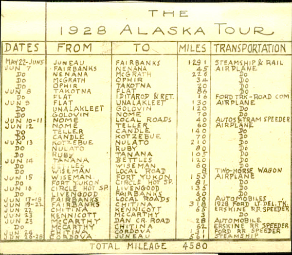
The photographs taken on the trip portray a country on the cusp of change, a rich, wild land just beginning to awaken to its potential. The purpose of the trip was to ascertain the need for more highways in Alaska and to discern the work already done on various existing routes such as the Richardson Highway; in 1928 there were less than 500 miles of paved roads in the entire state (363 miles on the Richardson Highway and the first 44 miles of the Steese Highway). The trip to northern and interior Alaska was the first extensive trip by airplane made by an Alaskan governor, and in total the small group traveled 4,580 miles, of which 385 were by steamship, 467 by rail, 281 by railroad speeders (automobiles adapted to ride on the rails), 432 by truck and automobile, 8 by horse and wagon and 2,007 by air.
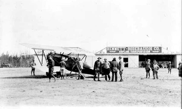
Over three dozen photographs are available to view online at the Alaska Digital Archives, including "Bill and wife at their cabin on Ophir-Takotna Road. These people are mining placer gold;” "Freighting on Yukon Highway near Goldstream;” "Tunnel at head of Fox Gulch, tapping Chatanika River watershed for for dredges in Goldstream;” "Gold Dredge at Flat;” "Cabin on Nome-Shelton tram near Nome bridge;” "Gas-driven speeder on Nome-Shelton tram;” "The graveyard at Nulato;” "Fort Yukon Hotel;” "Alaska Road Commission house at Sallchaket;” and many more. There are many photos of the various airfields they utilized, including Fairbanks, Nenana, Unalakleet, Nulato, Wiseman, and Bettles.
An excerpt from the Governor’s Report to the Secretary of the Interior, 1928
In May and June, 1928, the governor, accompanied by the president of the Alaska Road Commission and the Territorial highway engineer, made an extended tour of the interior sections of the Territory in an airplane. This is the first time that a long trip of this kind has been undertaken. The journey began at Fairbanks June 7. The party proceeded to Tacotna, stopping at Nenana, McGrath, and Ophir en route. It was the intention to visit Bethel on the lower Kuskokwim, but because of high water which covered the landing fields this part of the trip had to be abandoned. June 9 a flight was made to Nome with stops en route at Unalakleet and Golovin. Two days were spent in Nome. June 12 the party proceeded to Kotzebue with short stops at Teller and Candle. June 13 flights proceeded to Nulato on the Yukon, thence to Ruby and arrived at Tanana in the evening. June 14, after inspecting the Government hospital and hospital boat, the party went to Wiseman on the upper Koyukuk, having landed at Bettles en route. June 15 flight was made to Fort Yukon, thence to Circle Hot Springs, and on June 16 ended the trip at Fairbanks, having flown from Circle Hot Springs by way of Tolovana. The entire trip of about 2,500 miles was accomplished without difficulty of any kind and was a further demonstration of the possibility of safe flying in Alaska. The success of the trip was due to the excellent equipment and the skill of the pilot. To cover the same territory by ordinary transportation facilities would have required about one year.
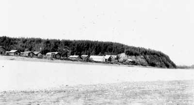
The photo below shows the Governor and his party at Unalakleet. They began by taking passage on a steamship from Juneau to Seward, then riding the still-new Alaska Railroad, opened only five years before, from Seward, through Anchorage and the Matanuska Valley, past Talkeetna, through Broad Pass to Cantwell, Healy, Nenana, and finally to Fairbanks, where his trip officially began.

George Alexander Parks
George Alexander Parks was born in Denver, Colorado on May 29, 1883. He graduated from the Colorado School of Mines in 1906 and came to Alaska in 1907, at the age of 24, to work as a mineral examiner for the U.S. Land Office. Following his military service in the First World War, Parks returned to Alaska as chief of the field division of the General Land Office. In 1924, he became Assistant Superintendent of Surveys and Public Lands, and in 1925 he was appointed the 11th governor of Alaska by President Calvin Coolidge.
George Parks' term of office was largely uneventful. Among the issues he dealt with were the reduction in federal funding for the United States Geological Survey and the elimination of all but two of the territory's agricultural experiment stations. He initiated a contest among school children to design a territorial flag, resulting in Benny Benson’s winning design of “eight stars of gold on a field of blue” in 1927.
Parks was reappointed for a second gubernatorial term in 1929, and when that term expired in 1933, he rejoined the U.S. Dept. of Interior as a district engineer for Alaska. During World War II he worked on military projects in Alaska, and he was awarded a Distinguished Achievement Award from the Colorado School of Mines in 1950. George Parks died on May 11, 1984, just a few weeks short of his 101st birthday. In 1975 the 323 mile long Alaska Route 3, which begins near Wasilla and runs north to Fairbanks, was named the George Parks Highway in his honor.
The 1928 Annual Report of the Alaska Road Commission included a brief mention of the epic trip made by Gov. Parks and his associates: “The most comprehensive inspection of the resources, routes of communication, government and territorial establishments and aviation fields ever made in the territory during one continuous trip was made in June, 1928, by Hon. George A. Parks, Governor of Alaska, Maj. Malcolm Elliot, President of the Alaska Road Commission and Mr. R. J. Sommers, Territorial Highway Engineer. The scope of the trip is shown on the map accompanying this report, from which it is seen that during a trip aggregating 4,500 miles over 2,000 miles were covered by plane. Only by the use of aviation was it possible to cover so great a distance in so short a time.”
It is likely that Robert J. Sommers was the photographer as there are numerous photographs of Parks and Elliott but only one of Sommers, a civil engineer who came to Alaska in 1900. He served as superintendent of the Alaska Road Commission, as Secretary of Alaska, and the first territorial highway engineer for the state. In 1931, he formed his own construction company (R. J. Sommers Construction Company) with the former Governor Parks as his vice-president.


~•~